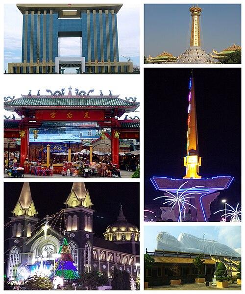
 VietnamProvinceBình DươngArea118.91 km2 (45.91 sq mi)Population373.105 • Density3.137/km2 (8.12/sq mi)Metro GDP (PPP, constant 2015 values) • Year2023 • Total$10.8 billion[1] • Per capita$22,400Time zoneUTC+7 (Indochina Time)Websitethudaumot.binhduong.gov.vn
 Thủ Dầu Một (listenⓘ) is the capital city of Bình Dương province, Vietnam, located at around 10°58′0″N 106°39′0″E / 10.96667°N 106.65000°E / 10.96667; 106.65000. The city has an area of 118.91 km², with a population of 373.105 (as of 2024),[2][3] and is located 20 km north of downtown Ho Chi Minh City, on the left bank of the Saigon River, upstream from the city.
Thu Dau Mot lies to the south of Bình Dương province and is contiguous with Saigon River:
- To the east is Tân Uyên
- To the west is Củ Chi district, Ho Chi Minh City
- To the south is Thuận An
- To the north is Bến Cát
Thủ Dầu Một has 14 wards:
- Phú Cường
- Chánh Mỹ
- Chánh Nghĩa
- Định Hòa
- Hiệp An
- Hiệp Thành
- Hòa Phú
- Phú Hòa
- Phú Lợi
- Phú Mỹ
- Phú Tân
- Phú Thọ
- Tân An
- Tương Bình Hiệp
In the past, some researchers have claimed that the name Thủ Dầu Một originates from Khmer language. However, other authors claim that the name Thủ Dầu Một is a compound of Vietnamese language roots, combining thủ, to "keep" or "guard", dầu referring to oil-producing trees of the genus Dipterocarpus, and the number một or "one". The toponym Dầu Một existed prior, in reference to large number of Dipterocarpus trees lining the port where there was a market in this area. In the 1940s, many of these were cut down; thus, the place name Thủ Dầu Một can be understood as "the only large oil tree growing, located next to the fort". Other toponyms in the area do follow similar tree + numeral structures, such as Xoài Tư (literally "Mango" + "Four") and Quéo Ba ("Mangifera reba" + "Three").[4]
According to a third oral tradition, in a fort (thủ) in Bình An, there was a large oil tree on the hill. Thus the original name would have been Thủ Dầu Miệt, which literally means "Oil-Tree Fort Region"; later, miệt underwent a sound change to một.[4]
In 1976, the National Assembly of Vietnam decided to merge Bình Dương Province and Bình Phước Province (which comprised the former provinces of Bình Long and Phước Long) into a new province called Sông Bé.[5] Thủ Dầu Một Town became the provincial capital of Sông Bé.[5]
In 2007, the Ministry of Construction recognized Thủ Dầu Một as a Grade-III urban area.[6][7]
On May 2, 2012, the government issued Resolution No. 11/NQ-CP on the establishment of Thủ Dầu Một City.[8][9][10]
On July 8, 2014, Thủ Dầu Một was recognized as a Grade-II urban area,[11][12][13] and on December 6, 2017, it officially became a Grade-I city under Bình Dương Province.[14]
Thủ Dầu Một has seen a rapid expansion and economic development since 1997, as the province has become an important industrial hub of the region. In January 2007, the district-level town then was officially recognized as a third-class town.[15] It became a city in July 2012.[16] There is a 4,200-ha urban-tech park under development. Thủ Dầu Một will be a modern city within the Hồ Chí Minh City Metropolitan Area (including Thủ Dầu Một, Nhơn Trạch, Tân An, Biên Hòa and parts of Đồng Nai and Bình Dương provinces).
It became a first-class city on 6 December 2017.[17]
Air travel is served by Ho Chi Minh City's Tan Son Nhat International Airport which is approximately 29 km south of Thủ Dầu Một. There are also direct road and bus links to the city from Ho Chi Minh City.
- Hội Khánh Temple
- Temple of lady Thiên Hậu
- Khu Đại Nam thế giới du lịch
- Market of Thủ Dầu Một
- The Ông temple
- The lacquer village of Tương Bình Hiệp
- The ceramic village
- Prison of Phú Lợi
- Ancient house by the market of Thủ Dầu Một
Media related to Thu Dau Mot at Wikimedia Commons
